Climate & Earth Intelligence
Built From Real Data
DataSnake builds planetary-scale intelligence systems by capturing, processing, and understanding environmental data across land, coast, and ocean — where decisions truly begin.
The Problem
Most climate, seismic, and environmental systems were built for land — while oceans, coastlines, and subsurface systems remain under-measured, delayed, or inferred.
- Critical data arrives late or fragmented
- Models rely on assumptions instead of measurements
- Decisions become reactive rather than predictive
What DataSnake Does
Collect
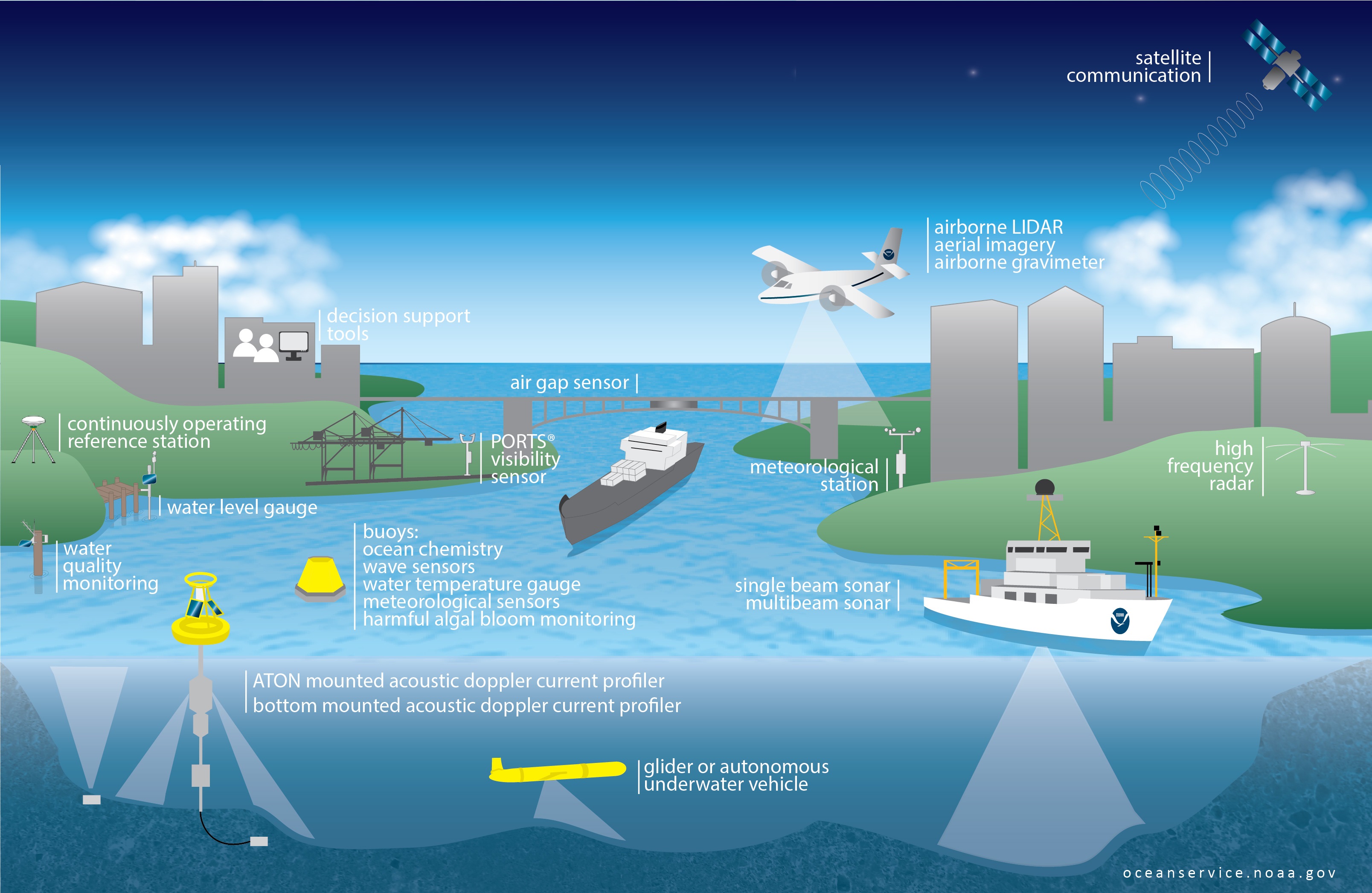
Ingest data from public datasets, sensors, edge systems, and marine deployments.
Process
Normalize, index, and align geo and time-series data at planetary scale.
Understand
Apply analytics, AI, and pattern detection to uncover risks, signals, and anomalies.
Deliver
Serve intelligence through APIs, dashboards, alerts, and downstream integrations.
How DataSnake Is Used
Coastal Intelligence
Monitor tides, storms, and ocean conditions to anticipate flooding and infrastructure risk.

Seismic Monitoring
Combine seismic and environmental signals to detect early warning patterns.

Climate Research
Provide researchers with continuous, high-resolution environmental datasets.
Real-Time, Personalized Monitoring
The ocean is Earth's heartbeat, but we monitor less than 20% of it. With unpredictable weather patterns, rising sea levels, and shifting tectonic activity, real-time, localized monitoring is more critical than ever.
Data Is the Moat
Public Sources
NOAA, USGS, NASA, and global open datasets — continuously updated and validated.
Proprietary Ingestion
On-ground sensors, edge systems, and future ocean-first deployments.
Unified Intelligence Model
Geo + time-series intelligence designed for environmental systems.
Looking Ahead
DataSnake is evolving toward continuous, ocean-first and subsurface data collection — enabling intelligence where data has historically been missing.
Build With Real-World Data
Talk to UsThe DataSnake Platform
A modular environmental intelligence system designed to operate across land, ocean, and subsurface domains — where traditional infrastructure cannot reach.
Distributed Data Capture
Collect real-time and historical data from public datasets, on-ground sensors, edge systems, and marine deployments.
Geo + Time-Series Core
Every signal is indexed spatially and temporally, enabling high-resolution environmental analysis at scale.
Intelligence Layer
Analytics, anomaly detection, and AI-driven insights reveal patterns invisible to siloed systems.
Delivery & Integration
Access insights through APIs, dashboards, alerts, and downstream integrations tailored to your workflows.
Request a Demo
See how DataSnake transforms raw environmental signals into actionable intelligence for climate, seismic, and ocean systems.
Early access is limited. We’re currently onboarding select partners and research teams.